-> alla pagina in italiano
-> zur deutschsprachigen Seite
-> vers la page en français
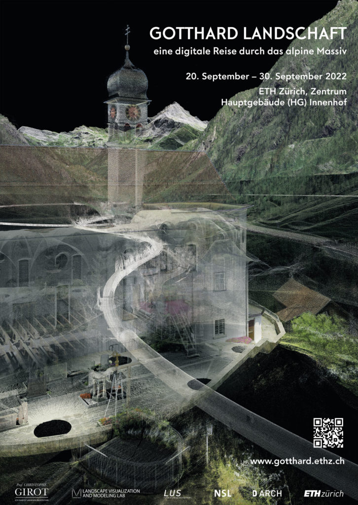
Exhibition duration: 20 September – 30 September 2022, in the context of the Swiss Digital Days
Exhibition venue: ETH Zurich, Centre Main Building (HG) Inner courtyard Rämistrasse 101, 8092 Zurich.
Opening hours main building: Monday – Friday: 06.00 – 22.00 Saturday, Sunday: 08.00 – 17.00
How to get there: Tram No. 6 / Tram No. 10 to the stop “ETH/Universitätsspital”, from the stop “Central” take the Polybahn to the Polyterrasse
Curator: Johannes Rebsamen
Director of Photography: Matthias Vollmer
Sound Composition: Ludwig Berger
Text and Communication: Isabelle Fehlmann
Project team: Prof. Christophe Girot, Johannes Rebsamen, Matthias Vollmer, Ludwig Berger, Isabelle Fehlmann, Dennis Häusler, Fabian Gutscher, Tom Bauer, Regula Schweizer
Organisation: ETH Zurich DARCH – Landscape Visualization and Modeling Lab LVML, Chair of Prof. Christophe Girot, Institute for Landscape and Urban Studies LUS
20 September 2022 at 18:00 Vernissage:
Round table on the Gotthard as an infrastructure landscape:
The Gotthard, iconic landscapes meet state-of-the-art infrastructure. The three-dimensional point cloud model makes the complex structures of the famous massif physically perceptible and visible in a unique way. What new possibilities does this open up in landscape planning and spatial modeling?
Impulse speech by Dr Chris Luebkeman (ETH Foresight)
Moderation Prof. Christophe Girot
Prof. Dr. Anette Freytag (Rutgers University USA)
Bruno Giussani (Global Curator, TED)
Prof. Dr. Adrienne Grêt-Regamey (ETH D-BAUG)
Prof. Matthias Kohler (ETH D-ARCH)
Dr. Thomas Robinson (SBB Strategic Foresight)
Dr. Nadine Schütz (Echora)
29 September 2022 at 18:00 Finissage:
Round table on the cultural heritage of the Gotthard landscape:
The development of the Gotthard passage through roads and tunnels characterizes the appearance of the alpine terrain. The digital representations make it possible to place existing structures of different traffic generations in one and the same picture. What do we read from their artful, transparent texture? What contribution can this form of documentation make to determining the cultural significance of the landscape?
Moderation Isabelle Fehlmann
Hans Danuser (Artist & Fotograf)
Prof. Dr. Michael Jakob (HEPIA)
Prof. Dr. Marion Sauter (Berner Fachhochschule)
Dr. Erika Flückiger Strebel (ASTRA)
The exhibition presents the latest results of an overarching research project that was launched fifteen years ago at the Professorship Girot. The focus is on a point cloud model of the alpine region, which has been continuously expanded and refined up to the new NEAT base tunnel. We have already presented various stages of development to the public, including in 2014 together with the Accademia di architettura Mendrisio at the Architecture Biennale in Venice. The heart of the current exhibition shows a journey through the digital landscape of the Gotthard from south to north. Above-ground rock formations, forests, villages, mountain passes, galleries and underground tunnels are placed in one and the same image, creating a new, poetic spatial experience.
Working with point cloud technology to convey and analyze complex spatial structures has a long tradition at our chair. Their light aesthetics combined with georeferenced accuracy allows a terrain to be accurately recorded with all its existing traces of development. Therefore, we use this technique as a central tool for our design teaching and research in landscape architecture.
The “Gotthard Landscape” project thus combines two target levels: the communication level, on which the digital model of the mountain massif can be viewed, listened to and flown through in a freely accessible manner, and the research level, on which new data and information are continuously integrated and combined. To this day, the interplay of mighty summit worlds with the most modern transport infrastructure nourishes the symbolism of Helvetic identity on the Gotthard. With our work, we want to contribute to preserving the landscape, which is important for the national heritage, in the diversity of its historical facets for the future.
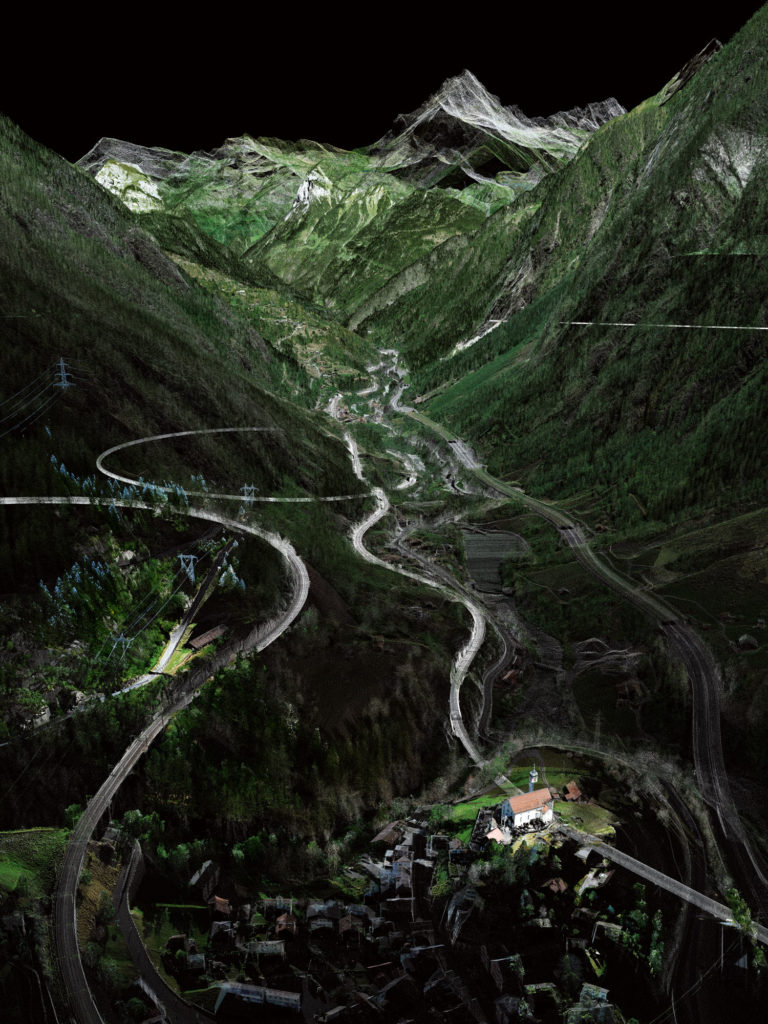
«Helicoidal Tunnel»
The helical tunnels near Wassen became popular symbols of engineering masterpieces: the curves carved into the rock made it possible to overcome a height difference of around 200 meters by rail over a short distance. The passengers experience them through the circular movements of the train, but they remain largely hidden from the eye. The transparent display with point clouds makes the characteristic circular structure visible in the surrounding landscape. The image relates the helical tunnels to their visual counterpart, the Wassen church. Enthroned on a rock, she appears three times from different heights, perspectives and even changing sides in front of the train windows. This made the church, built in 1734, one of the most famous landmarks when traveling on the Gotthard Railway.
«Transport Hub Göschenen»
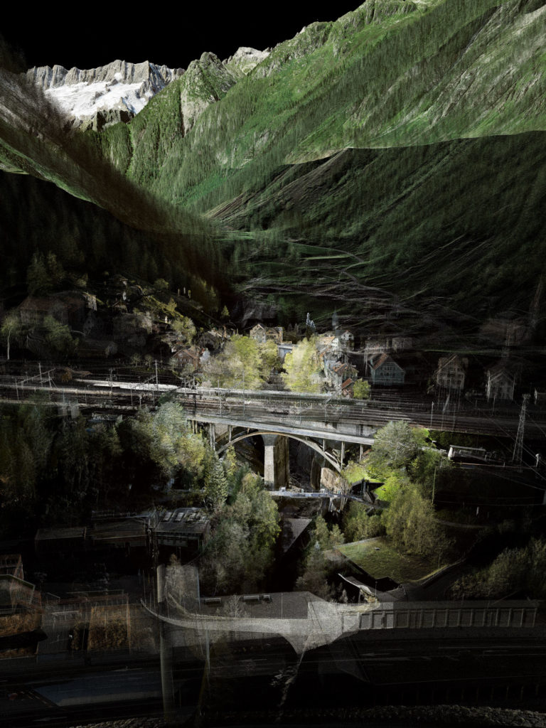
Different streams flow through Göschenen, whose porters block the narrow valley. With the opening of the Gotthard railway around 1882, the community of Uri became a milestone before the train entered the tunnel and only left again in southern Airolo. From 1980, another traffic channel bored its way through the mountain massif with the Autobahn Tunnel. The cantonal road to the pass and the Schöllenenbahn form further strands of the junction. Last but not least, the Reuss, a natural river, flows down the valley through Göschenen.
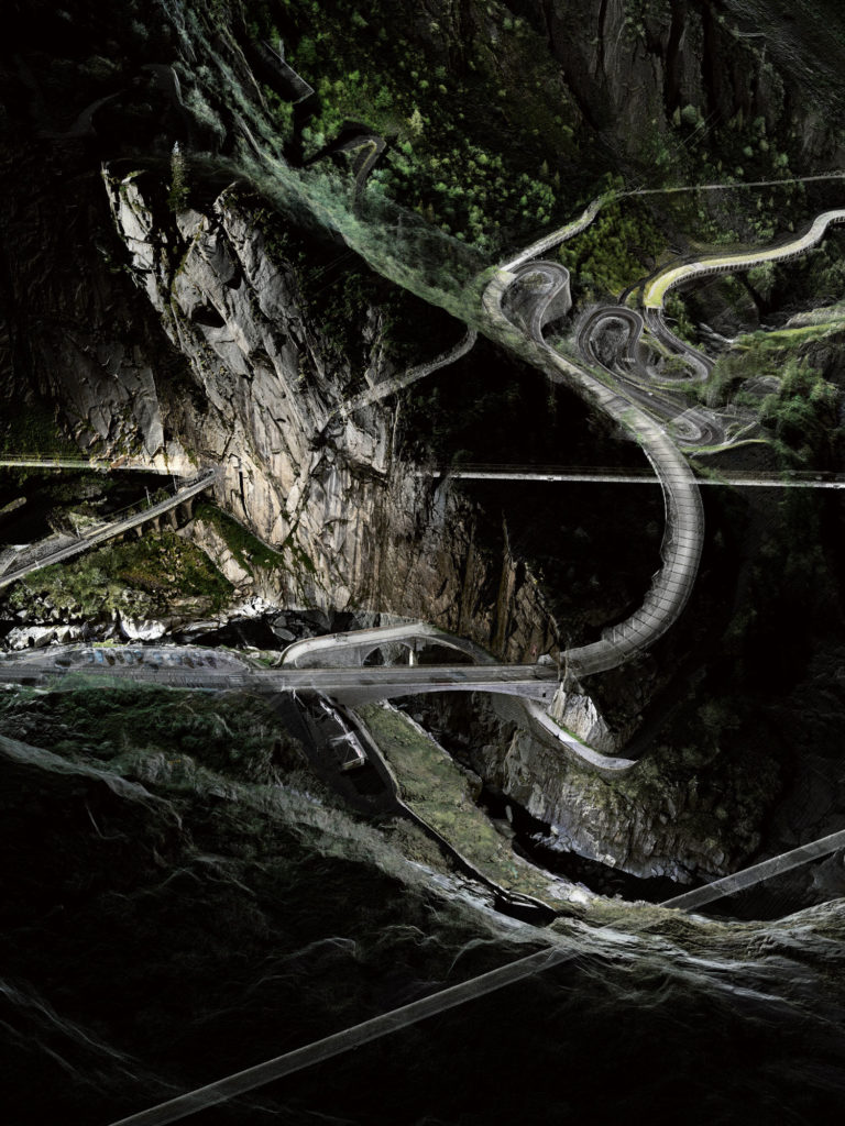
“Devil’s Bridge and other Traffic History Layers”
Due to the geographical conditions, the Gotthard has had strategic spatial significance as a passage between Northern Europe and the Mediterranean since the Middle Ages. Its development was tackled at different times according to the possibilities of the time. Still existing structures of different traffic generations are valuable testimonies of this. Here we see these layers in one and the same image. The traffic landscape of the Gotthard is characterized by the contrast between the old pass roads, which work their way up the terrain and the tunnel structures, which pave their way through the massif on a route that is as flat and straight as possible.
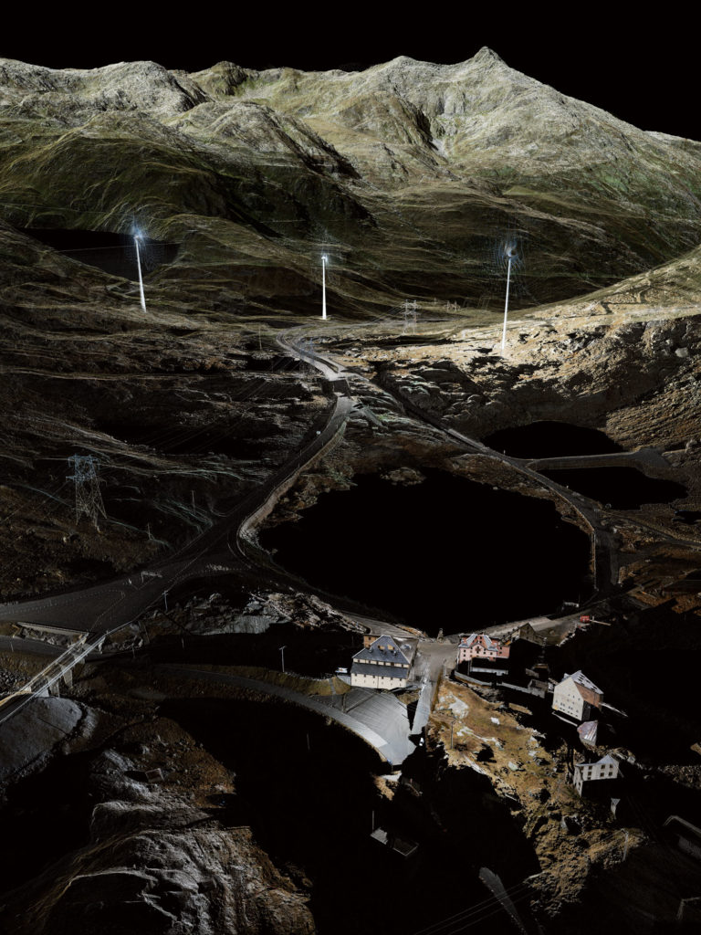
«Mountain Pass Threshold»
The picture shows the historic group of houses at the top of the pass. The old Sust, the former economic building of the mules, now houses a museum – as does the Sasso da Pigna fortress. They convey the history of the Gotthard between national symbol, military réduit and terrain of touristic and industrial developments. In addition to the historical traces, there are dam walls and wind turbines flanking the road at the top of the pass. As in the past, the Gotthard will also have a role to play in the future.
The installation in the main hall of the ETH Zentrum invites you to a physical space-sound experience of the Gotthard. A large-format south-north projection plays in the main hall, three-dimensional sound recordings complete the journey through the alpine region. While gliding over the massif we follow different paths through the territory – from above, close to the ground, even below the surface along a tunnel.
In the field of surveying, it is now possible to represent a complex environment in its entirety. Laser scanners depict their environment in millions of registered points, which are colored with the help of photographs. This results in a highly precise point cloud model. This enables sections, views, measurements, but also movements through the virtual Alpine region. Due to the high precision, density and large range of the laser scanner, a wide variety of scales can be covered – from the smallest spatial structures to larger landscape contexts. The transparent representation allows the landscape of the Gotthard to be experienced above, within and below the mountains.
At the same time, the aesthetic abstraction of the point clouds opens up space for the viewer’s imagination. Two virtual reality stations in the exhibition offer the opportunity to immerse yourself in the model in a very individual way. Equipped with VR glasses, visitors determine their own position in the interactively prepared environment. With a control device in hand, they can playfully try out different perspectives and viewing directions and maneuver themselves through the digital landscape.
Finally, a few selected views from the model are presented in large pictorial niches. Here the images can be studied up close with all their details. At the Gotthard, the spatial structures and traffic routes are in an interrelationship that continuously shapes the landscape. The point clouds make this process visible with their unique aesthetics. The depiction of characteristic subjects, such as the Devil’s Bridge or the Tremola, but also sections of the Gotthard Passage that have received little attention up to now, such as forests and rock formations, open up previously hidden spatial connections. For once, this iconic landscape can be viewed and experienced from a new perspective.
The video installation shows the entirety of the topological relationships of landscape topography and infrastructure buildings with a focus on the most important icons in the area between Erstfeld and Bodio.
On 11 November 2016, Christophe Girot spoke about “Point Cloud Modelling the Alpine Landscape” at the TEDx Talk in Zurich.

