
DOCTORAL STUDENT
Ben Gitai
ADVISOR
Professor Christophe Girot
CO – ADVISOR
Ita Heinze-Greenberg
Institute for the History and Theory of the Architecture (GTA)
PROJECT TIMEFRAME
Ongoing
PROJECT FUNDING
NIF
Mapping Power
“The whole world is a very narrow bridge” Rabbi Nachman of Breslov
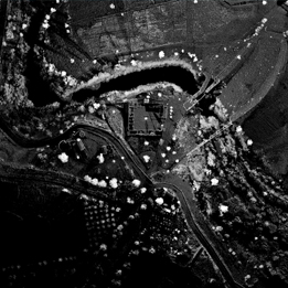
This thesis focuses on the case of the Naharayim site situated on the river of the Jordan Valley at the border between two countries, Jordan and Israel. The aim of this research is to investigate the metamorphosis of the landscape on the Jordan River over the past one-hundred and fifty years. It explores the terrain’s violent mutation through the use of cartography, ideology and geopolitics from the late 19th century to the present time. The site is composed of watercourses, borderlines, warpaths, power lines and surveillance sightlines following the human intervention behind the actual making of the territory. This research project addresses the production of space on this specific site and intends to prove that this landscape is not a natural feature, but a man-made system of artificial spaces. It functions and evolved not according to natural laws but in order to serve a set of socio-political forces. This dissertation intends to demonstrate the confluence of political and scientific approaches by the instrumental role of mapping, surveying and cartography on the Jordan Valley. This research might serve as a model for other contested areas, where the use of mapping surveys on the land has played an important role in the manifestation of landscape.
The thesis examines the implantation of boundaries on the ground and the act of transforming the land by the use of mapping surveys. In consequence, territories are influenced directly by the cartographer’s own relationship to the contested borders they draw. Invented to display objective facts, empirical maps frequently inspire tense discussions, with participants exhibiting a variety of observations that cannot be divorced from their unequal positions within the very terrains that they seek to portray
This dissertation will not determine which locations of a border are true, but it will consider how geographical knowledge, mapping surveys and ideology projected on the ground are combined together in a human act of power over nature. It will show how maps relate to a broad swath of digital media and knowledge, drawing out what is conditioned by the landscape discipline that is often taken to be natural and predetermined.