

Axonometric view of a point-cloud model edited from a laser scan to include a landscape design for the Rail Corridor in Tanjong Pagar, Singapore.
DOCTORAL STUDENT
ADVISOR
PROJECT TIMEFRAME
Ongoing
PROJECT FUNDING
Singapore-ETH Centre, National Research Foundation (NRF) Singapore
Shaping Physical Landscape
Exploring point cloud modeling as a site-specific design approach in landscape architecture.
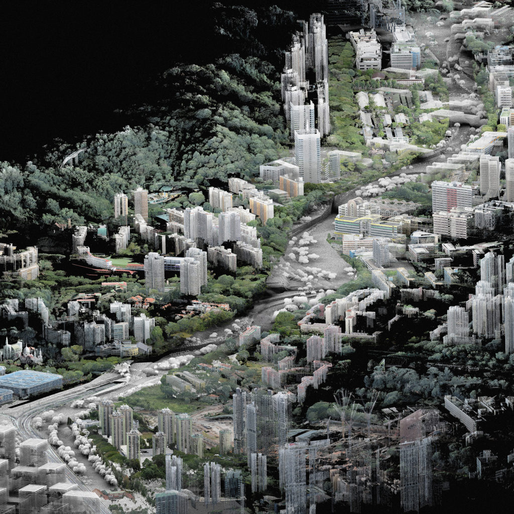
The aim of this doctoral thesis is to uncover an approach to integrate topological and formal features of a site into landscape design. This approach is made possible by manipulating geo-referenced data in the form of 3D point cloud models in order to shape proposals based on site-specific conditions.
Contemporary landscape design has a shortfall of methods for site-specific understanding and control of designed space. This doctoral thesis explores point cloud modelling as a potential method for developing landscape designs at a variety of scales in three-dimensional space. The research investigates how the design process can be conducted starting from the physical form of a site and proposes a new design approach to shape spatial qualities of the landscape. The method draws from point cloud models produced with the well-established technique of laser-scanning. Point cloud models provide an accurate three-dimensional representation of the landscape which allows to understand and work with the detailed form of the environment as part of the design process. A specific manipulation of point cloud models paired with a specific procedure for landscape design allows to develop design proposals with a stronger connection to the site and to its context. This design approach proposes both an operative and speculative frame that leads towards the reintroduction of three-dimensional thinking in landscape design at a variety of scales. The questions examined in this thesis draw from the multi-scalar, multi-contextual and trans-temporal qualities of point cloud models. The research investigates how point cloud modeling is applied to the fundamental actions of a landscape design process, including forming and grading of the topography, planting and composition of vegetation, the design of open space and infrastructure. It shows how fundamental questions about shaping the landscape can be answered with an increased knowledge of the site and how to develop more accurate design solutions for landscapes and cities.
The research is conducted with a mixed methods approach. First, it will define the point cloud model for site analysis to serve as a design investigation and to integrate a logic inherent to the temporal continuity of a site. Second it will define point cloud modelling as a topological design approach that helps conduct and test the design at hand, where actions in design correspond to actions in modelling. Third it will investigate with a case study how the use of point cloud modelling in landscape architecture can influence the design practice and the physical shaping of the environment.
By developing the spatial approach in landscape design, the process of point cloud modeling allows to integrate inputs from adjacent disciplinary fields that draw from the form of the site. These qualities are investigated in an interdisciplinary collaboration within the Module “Ecosystem Services in Urban Landscapes” at the Future Cities Laboratory and will inform a feedback loop on heat-mitigating landscapes with simulations performed on design scenarios. The thesis takes a series of case studies in which the design process has been led using point cloud modelling. The case studies are developed as Design Research Studios at the ETH in Zurich and at the SUTD in Singapore.
Teaching related to the doctoral thesis by Philipp RW Urech: