

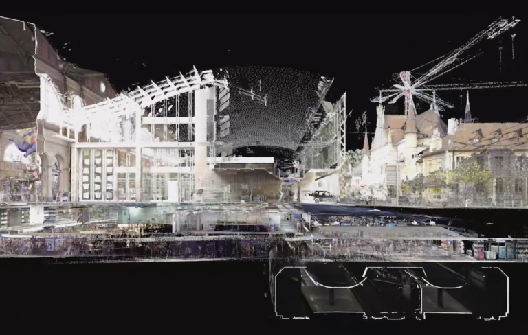
Central Station Zürich, 2018, © SCANVISION GmbH
DOCTORAL STUDENT
ADVISOR
PROJECT TIMEFRAME
Ongoing
PROJECT PARTNER
Urban Underground: Connecting the urban landscape with it’s underground
The design of the urban landscape begins underground. The soil is the breeding ground for development on the surface. The supply infrastructure of fluids, energy and telecommunications of a city lies beneath the surface and, like a cardiovascular system, ensures the inflow and outflow of incoming and outgoing entities. The constant supply leads to a permanent and essential exchange between these worlds. In the future, the demands on the underground space will increase.The changing environment, population growth and ongoing urbanisation require its more intensive use of the underground. Technological progress makes it possible to penetrate deeper and deeper into the ground with buildings and infrastructures, in addition to the development of new applications such as geothermal energy or district heating. The city is also expanding further below the surface.The subsoil is thereby seen as a resource that may be consumed and is thus becoming scarcer.
In the urban context, the built, above-ground space is clearly assigned the main role. In addition to direct human perception, extensive and detailed models of the above-ground urban landscape now exist. These end at the earth’s surface. Representations of the underground are mostly based on two-dimensional plans. The complex overlays of different structures are difficult to represent in a comprehensible way and shape the perception of the underground. The lack of awareness of precise documentation and tracking makes sustainable development difficult.
The three-dimensional point cloud representation based on geodata marks a paradigm shift: it not only enables a more detailed representation of the complex urban landscape including its detailed vegetation, but also lends the surface texture of the model an almost haptic quality. At the same time, it allows the spatial experience in motion; an essential aspect for the conscious perception of space and temporality in the model. Navigation in the model overcomes the separate consideration of territorial view and individual user perspective. The point cloud model resembles a multi-dimensional ‘X-ray’ of the landscape in which the spatial staggering of layers can be made visible at any time.
For the urban landscape of the future, the subsoil must be more strongly included and its potentials anchored in the general consciousness. If it is not taken into account, a bottleneck can develop in the soil, which will have an impact on urban planning, costs, environmental impacts, CO2 balance, traffic and subsequently on the quality of life in the city. Therefore, the urban landscape and its soil should be read and planned as a unit. To achieve this, the subsoil must be made visible and legible, its perception must advance into the third dimension. In the context of this work, the subsoil is to be thought of as part of the urban landscape and the urban ecosystem.