-> alla pagina in italiano
-> to the english website
-> vers la page en français
Ausstellungsdauer: 20. September – 30. September 2022, im Rahmen der Schweizer Digitaltage
Ausstellungsort: ETH Zürich, Zentrum Hauptgebäude (HG) Innenhof Rämistrasse 101, 8092 Zürich
Öffnungszeiten Hauptgebäude: Montag – Freitag: 06.00 – 22.00 Uhr Samstag, Sonntag: 08.00 – 17.00 Uhr
Anfahrt: Tram Nr. 6 / Tram Nr. 10 bis Haltestelle «ETH/Universitätsspital» Ab Haltestelle «Central» mit der Polybahn bis zur Polyterrasse
Kurator: Johannes Rebsamen
Director of Photography: Matthias Vollmer
Sound Composition: Ludwig Berger
Text und Kommunikation: Isabelle Fehlmann
Projekt-Team: Prof. Christophe Girot, Johannes Rebsamen, Matthias Vollmer, Isabelle Fehlmann, Ludwig Berger, Dennis Häusler, Fabian Gutscher, Tom Bauer, Regula Schweizer
Organisation: ETH Zurich DARCH – Landscape Visualization and Modeling Laboratory LVML, Chair of Prof. Christophe Girot, Institute for Landscape and Urban Studies LUS
Mit der Landschaft des Gotthards sind zahlreiche Geschichten und Mythen verbunden. Im kollektiven Bildgedächtnis der Schweiz ist der Gotthard als integraler Bestandteil der Alpen verankert, nicht als Berg aber als alpiner Übergang. Historische Spuren verschiedenster Epochen bezeugen seine Bedeutung als Passage zwischen politischen und wirtschaftlichen Zentren, an der verschiedene Kulturräume aufeinandertreffen.
20. September 2022 um 18:00 Uhr Vernissage:
Round Table zum Gotthard als Infrastrukturlandschaft:
Am Gotthard treffen ikonische Landschaftsbilder auf modernste Infrastrukturen. Das dreidimensionale Punktwolken-Modell macht die komplexen Strukturen des berühmten Massivs auf einzigartige Weise physisch spürbar und sichtbar. Welche neuen Möglichkeiten eröffnen sich dadurch in der Landschaftsplanung und Raummodellierung?
Impulsreferat von Dr. Chris Luebkeman (ETH Foresight)
Moderation Prof. Christophe Girot
Prof. Dr. Anette Freytag (Rutgers University USA)
Bruno Giussani (Global Curator, TED)
Prof. Dr. Adrienne Grêt-Regamey (ETH D-BAUG)
Prof. Matthias Kohler (ETH D-ARCH)
Dr. Thomas Robinson (SBB Strategic Foresight)
Dr. Nadine Schütz (Echora)
29. September 2022 um 18:00 Uhr Finissage:
Round Table zum kulturellen Erbe der Gotthard Landschaft:
Die Erschliessung der Gotthardpassage durch Strassen und Tunnel prägt die Erscheinung des alpinen Terrains. Die digitalen Darstellungen erlauben es, bestehende Strukturen unterschiedlicher Verkehrsgenerationen in ein und dasselbe Bild zu setzten. Was lesen wir aus ihrer kunstvoll anmutenden, transparenten Textur? Welchen Beitrag kann diese Form der Dokumentation leisten, um die kulturelle Bedeutung der Landschaft zu ermitteln?
Moderation Isabelle Fehlmann
Hans Danuser (Künstler & Fotograf)
Prof. Dr. Michael Jakob (HEPIA)
Prof. Dr. Marion Sauter (Berner Fachhochschule)
Dr. Erika Flückiger Strebel (ASTRA)
Die Videoinstallation zeigt die Gesamtheit der topologischen Verhätlnisse von landschaftlicher Topographie und Infrastrukturbauten mit Fokus auf die wichtigsten Ikonen im Gebiet zwischen Erstfeld und Bodio (Trailer).
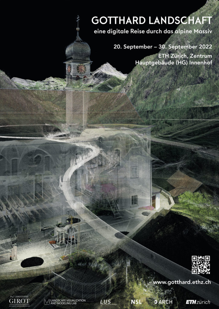
Die Ausstellung präsentiert die aktuellsten Ergebnisse eines übergeordneten und vor fünfzehn Jahren ins Leben gerufenen Forschungsprojekts an der Professur Girot. Im Mittelpunkt steht ein Punktwolken-Modell der alpinen Region, das bis zum neuen NEAT Basistunnel stetig erweitert und verfeinert wurde. Verschiedene Entwicklungsstufen präsentierten wir schon der Öffentlichkeit, unter anderem 2014 zusammen mit der Accademia di architettura Mendrisio an der Architekturbiennale in Venedig. Das Herzstück der aktuellen Ausstellung zeigt eine Reise durch die digitale Landschaft des Gotthards von Süd nach Nord. Dabei werden überirdische Felsformationen, Wälder, Dörfer, Passstrassen, Galerien und unterirdische Tunnel in ein und dasselbe Bild gesetzt und bewirken so eine neue, poetische Raumerfahrung.
Die Arbeit mit der Punktwolken-Technologie zur Vermittlung und Analyse komplexer räumlicher Strukturen hat an unserem Lehrstuhl Tradition. Ihre lichte Ästhetik kombiniert mit georeferenzierter Exaktheit erlaubt, ein Terrain mit all seinen vorhandenen Entwicklungsspuren akkurat zu erfassen. Deshalb nutzen wir diese Technik als ein zentrales Instrument für unsere Entwurfslehre und Forschung in der Landschaftsarchitektur.
Das Projekt «Gotthard Landschaft»verbindet somit zwei Zielebenen: die Vermittlungsebene, auf der das digitale Modell des Bergmassivs frei zugänglich betrachtet, belauscht und durchflogen werden kann, und die Forschungsebene, auf der laufend neue Daten und Informationen integriert und kombiniert werden. Bis heute nährt am Gotthard das Zusammenspiel von mächtigen Gipfelwelten mit modernsten Verkehrsinfrastrukturen die Symbolik der helvetischen Identität. Mit unserer Arbeit wollen wir dazu beitragen, die für das nationale Erbe bedeutsame Landschaft in der Vielfalt ihrer historischen Facetten für die Zukunft zu erhalten.
«Kehrtunnel»
Die Kehrtunnel bei Wassen wurden zu populären zu Symbolen ingenieurtechnischer Meisterleistung: Die in den Fels geschlagenen Kurven ermöglichten es auf kurzer Distanz rund 200 Höhenmeter mit der Eisenbahn zu überwinden. Die Passagiere erleben sie durch die kreisförmigen Bewegungen des Zuges, dem Auge bleiben sie aber zu weiten Teilen verborgen. Die transparente Darstellung mit Punktwolken macht für einmal die charakteristische Kreisstruktur in der umgebenden Landschaft sichtbar. Das Bild setzt die Kehrtunnel in Beziehung zu ihrem visuellen Gegenstück, der Kirche von Wassen. Auf einem Felsen thronend taucht sie dreimal aus verschiedenen Höhen, Perspektiven und gar mit Seitenwechsel vor den Zugfenstern auf. Dadurch wurde die 1734 erbaute Kirche zu einem der berühmtesten Orientierungspunkte auf der Reise mit der Gotthardbahn.
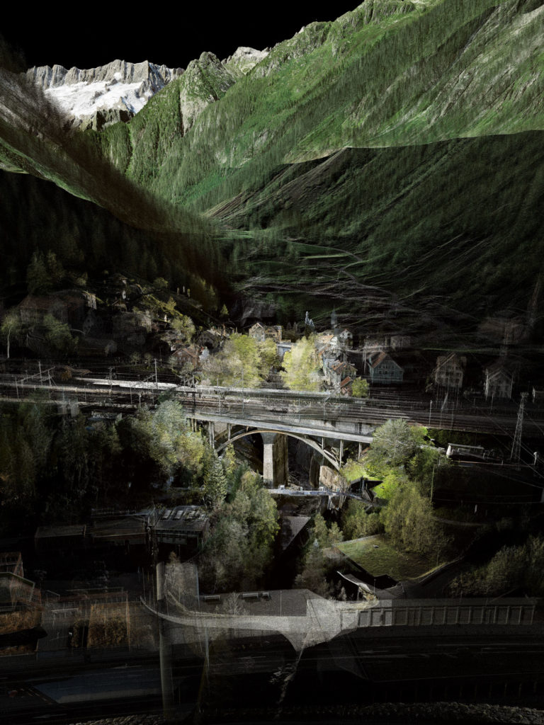
«Verkehrsknotenpunkt Göschenen»
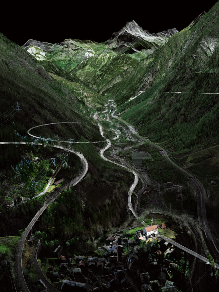
Unterschiedlichen Ströme durchfliessen Göschenen, deren Träger das enge Tal verbauen. Mit der Eröffnung der Gotthardeisenbahn um 1882 wurde die Urner Gemeinde zur Wegmarke, bevor der Zug in den Tunnel ein- und erst im südlichen Airolo wieder ausfährt. Mit dem Autobahntunnel bohrte sich ab 1980 ein weiterer Verkehrskanal durch das Bergmassiv. Die Kantonsstrasse zum Pass und die Schöllenenbahn bilden weitere Stränge des Knotenpunktes. Zu guter Letzt fliesst mit der Reuss ein natürlicher Fluss durch Göschenen das Tal hinab.
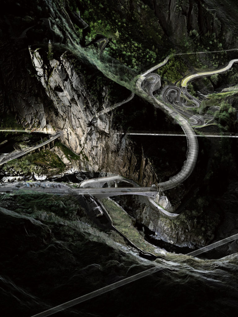
«Teufelsbrücke und weitere verkehrshistorische Schichten»
Aufgrund der geografischen Verhältnisse hat der Gotthard schon seit dem Mittelalter eine raumstrategische Bedeutung als Passage zwischen Nordeuropa und dem Mittelmeerraum. Seine Erschliessung wurde in den verschiedenen Zeiten gemäss den damaligen Möglichkeiten in Angriff genommen. Noch bestehende Strukturen unterschiedlicher Verkehrsgenerationen sind wertvolle Zeugnisse davon. Hier sehen wir diese Schichten in ein und demselben Bild. Die Verkehrslandschaft Gotthard ist geprägt vom Gegensatz zwischen den alten Passstrassen, die sich dem Terrain entlang die Höhenmeter hinaufarbeiten, und den Tunnelbauwerken, die ihre Linien auf möglichst flachem und geradem Weg durch das Massiv bahnen.
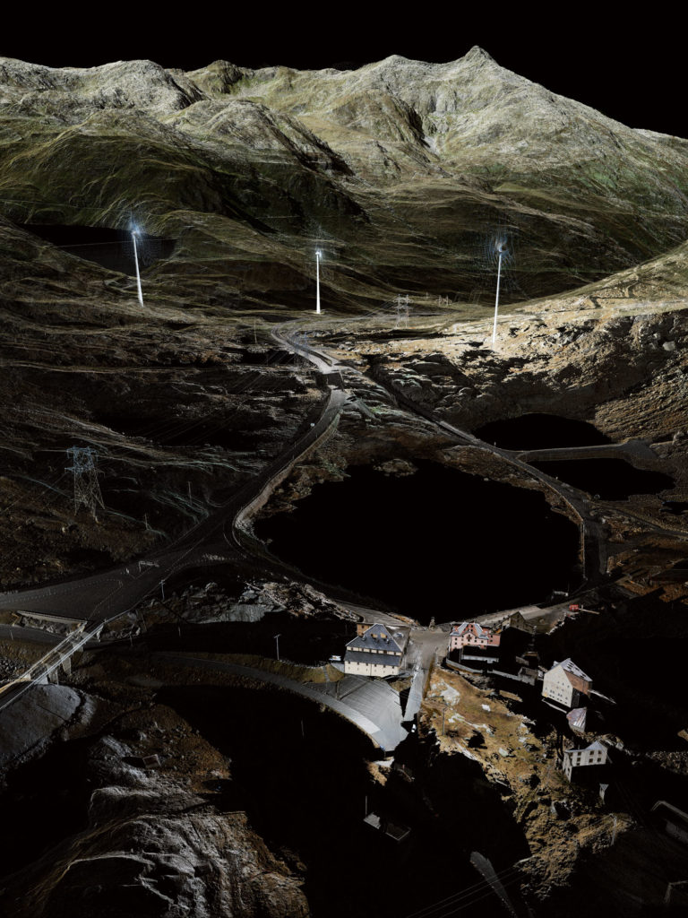
«Passhöhe»
Das Bild zeigt die historische Häusergruppe auf der Passhöhe. Die alte Sust, das ehemalige Wirtschaftsgebäude der Säumer, birgt heute ein Museum – so auch die Festungsanlage Sasso da Pigna. Sie vermitteln die Geschichte des Gotthards zwischen Nationalsymbol, militärischem Réduit und Terrain touristischer und industrieller Entwicklungen. Neben den historischen Spuren existieren heute auf der Passhöhe Staumauern und Windräder flankieren die Strasse. Wie in der Vergangenheit wird der Gotthard auch in der Zukunft seine Rolle zu spielen haben.
Die Installation in der Haupthalle des ETH Zentrums lädt ein zu einem physischen Raum-Klang-Erlebnis des Gotthards. Eine grossformatige Süd-Nord-Projektion bespielt die Halle, dreidimensionale Klangaufnahmen vervollständigen die Reise durch die alpine Region. Beim Hinweggleiten über das Bergmassiv folgen wir unterschiedlichen Wegen durch das Territorium – aus der Höhe, nah am Boden, einmal gar unter der Oberfläche entlang eines Tunnels.
Im Bereich der Vermessung ist es heute möglich, eine komplexe Umgebung in ihrer Gesamtheit darzustellen. Laserscanner bilden ihre Umwelt in Millionen von registrierten Punkten ab, welche mit Hilfe von Fotografien eingefärbt werden. So ergibt sich ein hochpräzises Punktwolken-Modell. Dieses ermöglicht Schnitte, Ansichten, Messungen, aber auch Bewegungen durch den virtuellen Alpenraum. Durch die hohe Präzision, Dichte und grosse Reichweite des Laserscanners können verschiedenste Massstäbe abgedeckt werden – von kleinsten räumlichen Strukturen bis hin zu grösseren landschaftlichen Zusammenhängen. Dabei erlaubt die transparente Darstellung, die Landschaft des Gotthards über, innerhalb und unter den Bergen erfahrbar zu machen.
Zugleich eröffnet die ästhetische Abstraktion der Punktwolken Raum für die Imagination der betrachtenden Person. Zwei Virtual-Reality-Stationen bieten in der Ausstellung die Möglichkeit, ganz individuell in das Modell einzutauchen. Ausgestattet mit einer VR-Brille bestimmen die Besucherinnen und Besucher ihren Standpunkt in der interaktiv aufbereiteten Umgebung selbst. Mit einem Steuergerät in der Hand können sie spielerisch verschiedene Blickwinkel wie auch Blickrichtungen ausprobieren und sich durch die digitale Landschaft manövrieren.
Schliesslich werden in grossen Bildernischen einige ausgewählte Ansichten aus dem Modell präsentiert. Hier lassen sich die Darstellungen aus der Nähe mit all ihren Details studieren. Die räumlichen Strukturen und die Verkehrswege stehen am Gotthard in einem Wechselverhältnis, das die Landschaft fortlaufend formt. Die Punktwolken machen diesen Prozess mit ihrer einzigartigen Ästhetik sichtbar. Die Darstellung von charakteristischen Sujets, wie die Teufelsbrücke oder die Tremola, aber auch von bisher weniger beachteten Abschnitten der Gotthardpassage, wie Wälder und Felsformationen, eröffnen dabei bisher verborgene räumliche Zusammenhänge. So kann diese ikonische Landschaft für einmal aus einer neuen Perspektive betrachtete und erlebt werden.
Die Videoinstallation zeigt die Gesamtheit der topologischen Verhätlnisse von landschaftlicher Topographie und Infrastrukturbauten mit Fokus auf die wichtigsten Ikonen im Gebiet zwischen Erstfeld und Bodio (Full Version).
Am 11. November 2016 sprach Christophe Girot beim TEDx Talk in Zürich über “Point Cloud Modelling the Alpine Landscape”.