Case Studies
HOME | RESEARCH PROJECT | CONCEPTS
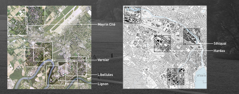
The Experimenting Proximity project focused on situations characterized by particular “edge-condition landscapes”: the Geneva and Zurich 1 x 1 km sites share this quality. They can be described as sites where a conglomeration of different urban landscapes may be observed at the proximity scale. It is fair to assume that, in the near future, these areas will be affected by densification, in line with contemporary urban planning and design trends. While the Hardau, Lignon and Meyrin case studies enabled us to rethink the qualities of three satellite suburbs of a decidedly modernist stamp, the other examples were representative of fringe areas with a more mixed pattern of urban materials – mixed use of residential, commercial, and industrial forms, as well as larger environmental and transport infrastructures.
MEYRIN CITÉ
The Meyrin suburb, built between 1962 and 1963, was designed to house 16,000 people in close proximity to CERN (European Organization for Nuclear Research).
The district, made up of tall ranges of eight to ten storeys, is concentrically arranged on grassy terrain around a civic and commercial hub.
Mapping
LIBELLULES
The Libellules quarter, just beyond Geneva’s urban center, is characterised by the presence of a series of infrastructure services for urban scale transportation that link and yet separate elements in a mixed-residential neighborhood, replete with sports facilities, services, commercial areas, and green space.
Mapping
LIGNON
The Lignon satellite suburb, designed in 1962, is composed of a single megastructure roughly 1km in length housing 2,780 apartments. The building, which has a semi-linear form, sits on top of a promontory skirted by a meander of the Rhône and forms a large, open-sided court facing the riverbank. The surroundings are made up of a fine grain of individual houses on plots and a industrial area of small-scale services.
Mapping
VERNIER
Vernier is a ribbon settlement that dissolves into a cluster of residential spaces on the banks of the Rhône. It is articulated by a series of agricultural spaces that face the river to the south and the Jura Mountains to the north.
Mapping
HARDAU
Hardau is a neighborhood in a former working-class area of Zurich. The quarter could well be described as being at the fringe of the inner city, with courtyard construction verging on strip development. Moreover, a heterogeneous, highly fragmented intermediate area can be found. Symptomatic of such a fragmentary disposition, the Hardau municipal housing development in the middle of the perimeter practically constitutes a quarter within the quarter. It often seems that the question of the transitions and the ‘in-betweens’ has not been addressed, or has remained a fruitless one to this day. There are many indistinct in-between spaces whose complexity eludes a more abstract plan and graphic description.
Videos
SIHLQUAI
While the fragmentary heterogeneous structure of the Hardau perimeter represents a prevalent condition of the contemporary urban landscape to be addressed, the Sihlquai is the site of street prostitution in Zurich, whose precarious, inhuman state poses a distinct problematic. In this context, the accumulated examples from the Sihlquai perimeter build up or establish a line of argument, that leads us on from the morphological conditions of the Sihlquai to the observation of social traces. The argumentation states an interrelationship between these two aspects through the consequence-like structure of the sequential arrangement of the single videos, from S01 to S10. Then it crosses this two-dimensional causal view by contextualizing the Sihlquai itself with its close counterparts within the one-kilometer perimeter neighborhood.
Videos


